
Result of collection database search
28 April 2024
<<
Large Map: World | Europe | Africa | South America | North America | Asia | Australia | Sweden| Google Earth| Google Maps
COLLECTION REPORT
SOK-98-017
Coordinates available for 27 records of SOK-98-017
Retrieved 27 of 27 (500 records requested)
Order: Perciformes
Family: Ambassidae
Species: Parambassis roberti
Cat No: NRM 40872. N=3
Determiner: Britz, R 2008
Length:
Preparation: Liquid
Continent/Ocean: Asia
Country: MYANMAR State/Province: Kachin State
District: Municipality: Myitkyina
River Drainage: Ayeyarwaddy River Lake Basin:
Ocean:
Locality: Nan Kywe Chaung ca 10 km S from Myitkyina and ca 300 m to left from road
Field Number: SOK-98-017
Leg: Kullander, SO & Britz, R
Date: 25 Mar 1998
Object remarks:
Locality remarks: GPS coordinates noted in field diary as 25°20'20"N 97°16'57"E. This is at the southern tip of the collected area. Corrected here using Google Earth.
Order: Perciformes
Family: Badidae
Species: Badis corycaeus
Cat No: NRM 40877. N=14
Determiner: Kullander, SO 1999
Length: 11.0-27.6
Preparation: Liquid
Continent/Ocean: Asia
Country: MYANMAR State/Province: Kachin State
District: Municipality: Myitkyina
River Drainage: Ayeyarwaddy River Lake Basin:
Ocean:
Locality: Nan Kywe Chaung ca 10 km S from Myitkyina and ca 300 m to left from road
Field Number: SOK-98-017
Leg: Kullander, SO & Britz, R
Date: 25 Mar 1998
PARATYPE Badis corycaeus Kullander and Britz, 2002
Object remarks:
Locality remarks: GPS coordinates noted in field diary as 25°20'20"N 97°16'57"E. This is at the southern tip of the collected area. Corrected here using Google Earth.
Order: Perciformes
Family: Badidae
Species: Badis kyar
Cat No: NRM 40876. N=3
Determiner: Kullander, SO 1998
Length: 26.3-29.1
Preparation: Liquid
Continent/Ocean: Asia
Country: MYANMAR State/Province: Kachin State
District: Municipality: Myitkyina
River Drainage: Ayeyarwaddy River Lake Basin:
Ocean:
Locality: Nan Kywe Chaung ca 10 km S from Myitkyina and ca 300 m to left from road
Field Number: SOK-98-017
Leg: Kullander, SO & Britz, R
Date: 25 Mar 1998
PARATYPE Badis kyar Kullander and Britz, 2002
Object remarks:
Locality remarks: GPS coordinates noted in field diary as 25°20'20"N 97°16'57"E. This is at the southern tip of the collected area. Corrected here using Google Earth.
Order: Perciformes
Family: Badidae
Species: Badis kyar
Cat No: NRM 43002. N=17
Determiner: Kullander, SO 1998
Length: 8.7-24.7 mm SL
Preparation: Liquid
Continent/Ocean: Asia
Country: MYANMAR State/Province: Kachin State
District: Municipality: Myitkyina
River Drainage: Ayeyarwaddy River Lake Basin:
Ocean:
Locality: Nan Kywe Chaung ca 10 km S from Myitkyina and ca 300 m to left from road
Field Number: SOK-98-017
Leg: Kullander, SO & Britz, R
Date: 25 Mar 1998
PARATYPE Badis kyar Kullander and Britz, 2002
Object remarks:
Locality remarks: GPS coordinates noted in field diary as 25°20'20"N 97°16'57"E. This is at the southern tip of the collected area. Corrected here using Google Earth.
Order: Perciformes
Family: Badidae
Species: Badis kyar
Cat No: NRM 44925. N=1
Determiner: Kullander, SO 1999
Length: 28 mm SL
Preparation: Liquid
Continent/Ocean: Asia
Country: MYANMAR State/Province: Kachin State
District: Municipality: Myitkyina
River Drainage: Ayeyarwaddy River Lake Basin:
Ocean:
Locality: Nan Kywe Chaung ca 10 km S from Myitkyina and ca 300 m to left from road
Field Number: SOK-98-017
Leg: Kullander, SO & Britz, R
Date: 25 Mar 1998
PARATYPE Badis kyar Kullander and Britz, 2002
Object remarks: Photographed in preservative
Locality remarks: GPS coordinates noted in field diary as 25°20'20"N 97°16'57"E. This is at the southern tip of the collected area. Corrected here using Google Earth.
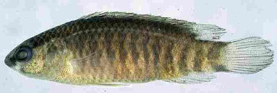
Image Order: Perciformes
Family: Badidae
Species: Dario hysginon
Cat No: NRM 40878. N=6
Determiner: Kullander, SO 1999
Length: 15.0-17.4
Preparation: Liquid
Continent/Ocean: Asia
Country: MYANMAR State/Province: Kachin State
District: Municipality: Myitkyina
River Drainage: Ayeyarwaddy River Lake Basin:
Ocean:
Locality: Nan Kywe Chaung ca 10 km S from Myitkyina and ca 300 m to left from road
Field Number: SOK-98-017
Leg: Kullander, SO & Britz, R
Date: 25 Mar 1998
PARATYPE Dario hysginon Kullander and Britz, 2002
Object remarks:
Locality remarks: GPS coordinates noted in field diary as 25°20'20"N 97°16'57"E. This is at the southern tip of the collected area. Corrected here using Google Earth.
Order: Cypriniformes
Family: Balitoridae
Species: Acanthocobitis mandalayensis
Cat No: NRM 40870. N=3
Determiner: Kottelat, M 2011
Length:
Preparation: Liquid
Continent/Ocean: Asia
Country: MYANMAR State/Province: Kachin State
District: Municipality: Myitkyina
River Drainage: Ayeyarwaddy River Lake Basin:
Ocean:
Locality: Nan Kywe Chaung ca 10 km S from Myitkyina and ca 300 m to left from road
Field Number: SOK-98-017
Leg: Kullander, SO & Britz, R
Date: 25 Mar 1998
Object remarks:
Locality remarks: GPS coordinates noted in field diary as 25°20'20"N 97°16'57"E. This is at the southern tip of the collected area. Corrected here using Google Earth.
Order: Cypriniformes
Family: Balitoridae
Species: Acanthocobitis sp.
Cat No: NRM 40882. N=2
Determiner: Kottelat, M 2011
Length:
Preparation: Liquid
Continent/Ocean: Asia
Country: MYANMAR State/Province: Kachin State
District: Municipality: Myitkyina
River Drainage: Ayeyarwaddy River Lake Basin:
Ocean:
Locality: Nan Kywe Chaung ca 10 km S from Myitkyina and ca 300 m to left from road
Field Number: SOK-98-017
Leg: Kullander, SO & Britz, R
Date: 25 Mar 1998
Object remarks:
Locality remarks: GPS coordinates noted in field diary as 25°20'20"N 97°16'57"E. This is at the southern tip of the collected area. Corrected here using Google Earth.
Order: Beloniformes
Family: Belonidae
Species: Xenentodon
Cat No: NRM 40890. N=1
Determiner: Åhlander, E 1998
Length:
Preparation: Liquid
Continent/Ocean: Asia
Country: MYANMAR State/Province: Kachin State
District: Municipality: Myitkyina
River Drainage: Ayeyarwaddy River Lake Basin:
Ocean:
Locality: Nan Kywe Chaung ca 10 km S from Myitkyina and ca 300 m to left from road
Field Number: SOK-98-017
Leg: Kullander, SO & Britz, R
Date: 25 Mar 1998
Object remarks:
Locality remarks: GPS coordinates noted in field diary as 25°20'20"N 97°16'57"E. This is at the southern tip of the collected area. Corrected here using Google Earth.
Order: Cypriniformes
Family: Cobitidae
Species: Lepidocephalichthys alkaia
Cat No: NRM 40881. N=6
Determiner: Kullander, SO 2016
Length:
Preparation: Liquid
Continent/Ocean: Asia
Country: MYANMAR State/Province: Kachin State
District: Municipality: Myitkyina
River Drainage: Ayeyarwaddy River Lake Basin:
Ocean:
Locality: Nan Kywe Chaung ca 10 km S from Myitkyina and ca 300 m to left from road
Field Number: SOK-98-017
Leg: Kullander, SO & Britz, R
Date: 25 Mar 1998
Object remarks:
Locality remarks: GPS coordinates noted in field diary as 25°20'20"N 97°16'57"E. This is at the southern tip of the collected area. Corrected here using Google Earth.
Order: Cypriniformes
Family: Cobitidae
Species: Lepidocephalichthys micropogon
Cat No: NRM 40880. N=6
Determiner: Kullander, SO 2016
Length:
Preparation: Liquid
Continent/Ocean: Asia
Country: MYANMAR State/Province: Kachin State
District: Municipality: Myitkyina
River Drainage: Ayeyarwaddy River Lake Basin:
Ocean:
Locality: Nan Kywe Chaung ca 10 km S from Myitkyina and ca 300 m to left from road
Field Number: SOK-98-017
Leg: Kullander, SO & Britz, R
Date: 25 Mar 1998
Object remarks:
Locality remarks: GPS coordinates noted in field diary as 25°20'20"N 97°16'57"E. This is at the southern tip of the collected area. Corrected here using Google Earth.
Order: Cypriniformes
Family: Cyprinidae
Species: Esomus caudiocellatus
Cat No: NRM 40888. N=1
Determiner: Kullander, SO 2010
Length:
Preparation: Liquid
Continent/Ocean: Asia
Country: MYANMAR State/Province: Kachin State
District: Municipality: Myitkyina
River Drainage: Ayeyarwaddy River Lake Basin:
Ocean:
Locality: Nan Kywe Chaung ca 10 km S from Myitkyina and ca 300 m to left from road
Field Number: SOK-98-017
Leg: Kullander, SO & Britz, R
Date: 25 Mar 1998
Object remarks:
Locality remarks: GPS coordinates noted in field diary as 25°20'20"N 97°16'57"E. This is at the southern tip of the collected area. Corrected here using Google Earth.
Order: Cypriniformes
Family: Cyprinidae
Species: Microrasbora sp.
Cat No: NRM 40886. N=5
Determiner: Kullander, SO 2007
Length:
Preparation: Liquid
Continent/Ocean: Asia
Country: MYANMAR State/Province: Kachin State
District: Municipality: Myitkyina
River Drainage: Ayeyarwaddy River Lake Basin:
Ocean:
Locality: Nan Kywe Chaung ca 10 km S from Myitkyina and ca 300 m to left from road
Field Number: SOK-98-017
Leg: Kullander, SO & Britz, R
Date: 25 Mar 1998
Object remarks:
Locality remarks: GPS coordinates noted in field diary as 25°20'20"N 97°16'57"E. This is at the southern tip of the collected area. Corrected here using Google Earth.
Order: Cypriniformes
Family: Cyprinidae
Species: Microrasbora sp.
Cat No: NRM 59712. N=1
Determiner: Kullander, SO 2007
Length:
Preparation: C&S
Continent/Ocean: Asia
Country: MYANMAR State/Province: Kachin State
District: Municipality: Myitkyina
River Drainage: Ayeyarwaddy River Lake Basin:
Ocean:
Locality: Nan Kywe Chaung ca 10 km S from Myitkyina and ca 300 m to left from road
Field Number: SOK-98-017
Leg: Kullander, SO & Britz, R
Date: 25 Mar 1998
Object remarks: C&S by TY Liao in 2008.
Locality remarks: GPS coordinates noted in field diary as 25°20'20"N 97°16'57"E. This is at the southern tip of the collected area. Corrected here using Google Earth.
Order: Cypriniformes
Family: Cyprinidae
Species: Oreichthys sp.
Cat No: NRM 40884. N=1
Determiner: Kullander, SO 1999
Length:
Preparation: Liquid
Continent/Ocean: Asia
Country: MYANMAR State/Province: Kachin State
District: Municipality: Myitkyina
River Drainage: Ayeyarwaddy River Lake Basin:
Ocean:
Locality: Nan Kywe Chaung ca 10 km S from Myitkyina and ca 300 m to left from road
Field Number: SOK-98-017
Leg: Kullander, SO & Britz, R
Date: 25 Mar 1998
Object remarks:
Locality remarks: GPS coordinates noted in field diary as 25°20'20"N 97°16'57"E. This is at the southern tip of the collected area. Corrected here using Google Earth.
Order: Cypriniformes
Family: Cyprinidae
Species: Puntius erythromycter
Cat No: NRM 56761. N=7
Determiner: Kullander, SO 2008
Length: 23.9-28.5 mm SL
Preparation: Liquid
Continent/Ocean: Asia
Country: MYANMAR State/Province: Kachin State
District: Municipality: Myitkyina
River Drainage: Ayeyarwaddy River Lake Basin:
Ocean:
Locality: Nan Kywe Chaung ca 10 km S from Myitkyina and ca 300 m to left from road
Field Number: SOK-98-017
Leg: Kullander, SO & Britz, R
Date: 25 Mar 1998
PARATYPE Puntius erythromycter Kullander, 2008
Object remarks:
Locality remarks: GPS coordinates noted in field diary as 25°20'20"N 97°16'57"E. This is at the southern tip of the collected area. Corrected here using Google Earth.
Order: Cypriniformes
Family: Cyprinidae
Species: Puntius thelys
Cat No: NRM 40883. N=1
Determiner: Kullander, SO 2008
Length: 36.7 mm SL
Preparation: Liquid
Continent/Ocean: Asia
Country: MYANMAR State/Province: Kachin State
District: Municipality: Myitkyina
River Drainage: Ayeyarwaddy River Lake Basin:
Ocean:
Locality: Nan Kywe Chaung ca 10 km S from Myitkyina and ca 300 m to left from road
Field Number: SOK-98-017
Leg: Kullander, SO & Britz, R
Date: 25 Mar 1998
PARATYPE Puntius thelys Kullander, 2008
Object remarks:
Locality remarks: GPS coordinates noted in field diary as 25°20'20"N 97°16'57"E. This is at the southern tip of the collected area. Corrected here using Google Earth.
Order: Cypriniformes
Family: Cyprinidae
Species: Puntius thelys
Cat No: NRM 40885. N=9
Determiner: Kullander, SO 2008
Length: 12.6-15.7 mm SL
Preparation: Liquid
Continent/Ocean: Asia
Country: MYANMAR State/Province: Kachin State
District: Municipality: Myitkyina
River Drainage: Ayeyarwaddy River Lake Basin:
Ocean:
Locality: Nan Kywe Chaung ca 10 km S from Myitkyina and ca 300 m to left from road
Field Number: SOK-98-017
Leg: Kullander, SO & Britz, R
Date: 25 Mar 1998
PARATYPE Puntius thelys Kullander, 2008
Object remarks:
Locality remarks: GPS coordinates noted in field diary as 25°20'20"N 97°16'57"E. This is at the southern tip of the collected area. Corrected here using Google Earth.
Order: Cypriniformes
Family: Cyprinidae
Species: Rasbora daniconius
Cat No: NRM 40887. N=3
Determiner: Åhlander, E 1998
Length:
Preparation: Liquid
Continent/Ocean: Asia
Country: MYANMAR State/Province: Kachin State
District: Municipality: Myitkyina
River Drainage: Ayeyarwaddy River Lake Basin:
Ocean:
Locality: Nan Kywe Chaung ca 10 km S from Myitkyina and ca 300 m to left from road
Field Number: SOK-98-017
Leg: Kullander, SO & Britz, R
Date: 25 Mar 1998
Object remarks:
Locality remarks: GPS coordinates noted in field diary as 25°20'20"N 97°16'57"E. This is at the southern tip of the collected area. Corrected here using Google Earth.
Order: Gasterosteiformes
Family: Indostomidae
Species: Indostomus paradoxus burmaspigg
Cat No: NRM 40889. N=3
Determiner: Kullander, SO 1998
Length:
Preparation: Liquid
Continent/Ocean: Asia
Country: MYANMAR State/Province: Kachin State
District: Municipality: Myitkyina
River Drainage: Ayeyarwaddy River Lake Basin:
Ocean:
Locality: Nan Kywe Chaung ca 10 km S from Myitkyina and ca 300 m to left from road
Field Number: SOK-98-017
Leg: Kullander, SO & Britz, R
Date: 25 Mar 1998
Object remarks:
Locality remarks: GPS coordinates noted in field diary as 25°20'20"N 97°16'57"E. This is at the southern tip of the collected area. Corrected here using Google Earth.
Order: Synbranchiformes
Family: Mastacembelidae
Species: Mastacembelus armatus
Cat No: NRM 40868. N=1
Determiner: Britz, R 2007
Length:
Preparation: Liquid
Continent/Ocean: Asia
Country: MYANMAR State/Province: Kachin State
District: Municipality: Myitkyina
River Drainage: Ayeyarwaddy River Lake Basin:
Ocean:
Locality: Nan Kywe Chaung ca 10 km S from Myitkyina and ca 300 m to left from road
Field Number: SOK-98-017
Leg: Kullander, SO & Britz, R
Date: 25 Mar 1998
Object remarks:
Locality remarks: GPS coordinates noted in field diary as 25°20'20"N 97°16'57"E. This is at the southern tip of the collected area. Corrected here using Google Earth.
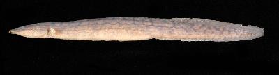
Image Order: Osteoglossiformes
Family: Notopteridae
Species: Notopterus notopterus
Cat No: NRM 40869. N=6
Determiner: Åhlander, E 1998
Length:
Preparation: Liquid
Continent/Ocean: Asia
Country: MYANMAR State/Province: Kachin State
District: Municipality: Myitkyina
River Drainage: Ayeyarwaddy River Lake Basin:
Ocean:
Locality: Nan Kywe Chaung ca 10 km S from Myitkyina and ca 300 m to left from road
Field Number: SOK-98-017
Leg: Kullander, SO & Britz, R
Date: 25 Mar 1998
Object remarks:
Locality remarks: GPS coordinates noted in field diary as 25°20'20"N 97°16'57"E. This is at the southern tip of the collected area. Corrected here using Google Earth.
Order: Siluriformes
Family: Siluridae
Species: Ompok
Cat No: NRM 40871. N=4
Determiner: Åhlander, E 1998
Length:
Preparation: Liquid
Continent/Ocean: Asia
Country: MYANMAR State/Province: Kachin State
District: Municipality: Myitkyina
River Drainage: Ayeyarwaddy River Lake Basin:
Ocean:
Locality: Nan Kywe Chaung ca 10 km S from Myitkyina and ca 300 m to left from road
Field Number: SOK-98-017
Leg: Kullander, SO & Britz, R
Date: 25 Mar 1998
Object remarks:
Locality remarks: GPS coordinates noted in field diary as 25°20'20"N 97°16'57"E. This is at the southern tip of the collected area. Corrected here using Google Earth.
Order: Gasterosteiformes
Family: Syngnathidae
Species: Microphis
Cat No: NRM 40873. N=1
Determiner: Åhlander, E 1998
Length:
Preparation: Liquid
Continent/Ocean: Asia
Country: MYANMAR State/Province: Kachin State
District: Municipality: Myitkyina
River Drainage: Ayeyarwaddy River Lake Basin:
Ocean:
Locality: Nan Kywe Chaung ca 10 km S from Myitkyina and ca 300 m to left from road
Field Number: SOK-98-017
Leg: Kullander, SO & Britz, R
Date: 25 Mar 1998
Object remarks:
Locality remarks: GPS coordinates noted in field diary as 25°20'20"N 97°16'57"E. This is at the southern tip of the collected area. Corrected here using Google Earth.
Order: Tetraodontiformes
Family: Tetraodontidae
Species: Leiodon cutcutia
Cat No: NRM 40874. N=18
Determiner: Kullander, SO 2014
Length: 33.1-56 mm SL
Preparation: Liquid
Continent/Ocean: Asia
Country: MYANMAR State/Province: Kachin State
District: Municipality: Myitkyina
River Drainage: Ayeyarwaddy River Lake Basin:
Ocean:
Locality: Nan Kywe Chaung ca 10 km S from Myitkyina and ca 300 m to left from road
Field Number: SOK-98-017
Leg: Kullander, SO & Britz, R
Date: 25 Mar 1998
Object remarks:
Locality remarks: GPS coordinates noted in field diary as 25°20'20"N 97°16'57"E. This is at the southern tip of the collected area. Corrected here using Google Earth.
Order: Tetraodontiformes
Family: Tetraodontidae
Species: Leiodon cutcutia
Cat No: NRM 40875. N=10
Determiner: Kullander, SO 2014
Length: 39.2-52.7 mm SL
Preparation: Liquid
Continent/Ocean: Asia
Country: MYANMAR State/Province: Kachin State
District: Municipality: Myitkyina
River Drainage: Ayeyarwaddy River Lake Basin:
Ocean:
Locality: Nan Kywe Chaung ca 10 km S from Myitkyina and ca 300 m to left from road
Field Number: SOK-98-017
Leg: Kullander, SO & Britz, R
Date: 25 Mar 1998
Object remarks:
Locality remarks: GPS coordinates noted in field diary as 25°20'20"N 97°16'57"E. This is at the southern tip of the collected area. Corrected here using Google Earth.
Order: Tetraodontiformes
Family: Tetraodontidae
Species: Leiodon cutcutia
Cat No: NRM 40879. N=1
Determiner: Kullander, SO 2014
Length: 9 mm SL
Preparation: Liquid
Continent/Ocean: Asia
Country: MYANMAR State/Province: Kachin State
District: Municipality: Myitkyina
River Drainage: Ayeyarwaddy River Lake Basin:
Ocean:
Locality: Nan Kywe Chaung ca 10 km S from Myitkyina and ca 300 m to left from road
Field Number: SOK-98-017
Leg: Kullander, SO & Britz, R
Date: 25 Mar 1998
Object remarks:
Locality remarks: GPS coordinates noted in field diary as 25°20'20"N 97°16'57"E. This is at the southern tip of the collected area. Corrected here using Google Earth.
Family: Ambassidae
Species: Parambassis roberti
Cat No: NRM 40872. N=3
Determiner: Britz, R 2008
Length:
Preparation: Liquid
Continent/Ocean: Asia
Country: MYANMAR State/Province: Kachin State
District: Municipality: Myitkyina
River Drainage: Ayeyarwaddy River Lake Basin:
Ocean:
Locality: Nan Kywe Chaung ca 10 km S from Myitkyina and ca 300 m to left from road
Field Number: SOK-98-017
Leg: Kullander, SO & Britz, R
Date: 25 Mar 1998
Object remarks:
Locality remarks: GPS coordinates noted in field diary as 25°20'20"N 97°16'57"E. This is at the southern tip of the collected area. Corrected here using Google Earth.
Order: Perciformes
Family: Badidae
Species: Badis corycaeus
Cat No: NRM 40877. N=14
Determiner: Kullander, SO 1999
Length: 11.0-27.6
Preparation: Liquid
Continent/Ocean: Asia
Country: MYANMAR State/Province: Kachin State
District: Municipality: Myitkyina
River Drainage: Ayeyarwaddy River Lake Basin:
Ocean:
Locality: Nan Kywe Chaung ca 10 km S from Myitkyina and ca 300 m to left from road
Field Number: SOK-98-017
Leg: Kullander, SO & Britz, R
Date: 25 Mar 1998
PARATYPE Badis corycaeus Kullander and Britz, 2002
Object remarks:
Locality remarks: GPS coordinates noted in field diary as 25°20'20"N 97°16'57"E. This is at the southern tip of the collected area. Corrected here using Google Earth.
Order: Perciformes
Family: Badidae
Species: Badis kyar
Cat No: NRM 40876. N=3
Determiner: Kullander, SO 1998
Length: 26.3-29.1
Preparation: Liquid
Continent/Ocean: Asia
Country: MYANMAR State/Province: Kachin State
District: Municipality: Myitkyina
River Drainage: Ayeyarwaddy River Lake Basin:
Ocean:
Locality: Nan Kywe Chaung ca 10 km S from Myitkyina and ca 300 m to left from road
Field Number: SOK-98-017
Leg: Kullander, SO & Britz, R
Date: 25 Mar 1998
PARATYPE Badis kyar Kullander and Britz, 2002
Object remarks:
Locality remarks: GPS coordinates noted in field diary as 25°20'20"N 97°16'57"E. This is at the southern tip of the collected area. Corrected here using Google Earth.
Order: Perciformes
Family: Badidae
Species: Badis kyar
Cat No: NRM 43002. N=17
Determiner: Kullander, SO 1998
Length: 8.7-24.7 mm SL
Preparation: Liquid
Continent/Ocean: Asia
Country: MYANMAR State/Province: Kachin State
District: Municipality: Myitkyina
River Drainage: Ayeyarwaddy River Lake Basin:
Ocean:
Locality: Nan Kywe Chaung ca 10 km S from Myitkyina and ca 300 m to left from road
Field Number: SOK-98-017
Leg: Kullander, SO & Britz, R
Date: 25 Mar 1998
PARATYPE Badis kyar Kullander and Britz, 2002
Object remarks:
Locality remarks: GPS coordinates noted in field diary as 25°20'20"N 97°16'57"E. This is at the southern tip of the collected area. Corrected here using Google Earth.
Order: Perciformes
Family: Badidae
Species: Badis kyar
Cat No: NRM 44925. N=1
Determiner: Kullander, SO 1999
Length: 28 mm SL
Preparation: Liquid
Continent/Ocean: Asia
Country: MYANMAR State/Province: Kachin State
District: Municipality: Myitkyina
River Drainage: Ayeyarwaddy River Lake Basin:
Ocean:
Locality: Nan Kywe Chaung ca 10 km S from Myitkyina and ca 300 m to left from road
Field Number: SOK-98-017
Leg: Kullander, SO & Britz, R
Date: 25 Mar 1998
PARATYPE Badis kyar Kullander and Britz, 2002
Object remarks: Photographed in preservative
Locality remarks: GPS coordinates noted in field diary as 25°20'20"N 97°16'57"E. This is at the southern tip of the collected area. Corrected here using Google Earth.
Image Order: Perciformes
Family: Badidae
Species: Dario hysginon
Cat No: NRM 40878. N=6
Determiner: Kullander, SO 1999
Length: 15.0-17.4
Preparation: Liquid
Continent/Ocean: Asia
Country: MYANMAR State/Province: Kachin State
District: Municipality: Myitkyina
River Drainage: Ayeyarwaddy River Lake Basin:
Ocean:
Locality: Nan Kywe Chaung ca 10 km S from Myitkyina and ca 300 m to left from road
Field Number: SOK-98-017
Leg: Kullander, SO & Britz, R
Date: 25 Mar 1998
PARATYPE Dario hysginon Kullander and Britz, 2002
Object remarks:
Locality remarks: GPS coordinates noted in field diary as 25°20'20"N 97°16'57"E. This is at the southern tip of the collected area. Corrected here using Google Earth.
Order: Cypriniformes
Family: Balitoridae
Species: Acanthocobitis mandalayensis
Cat No: NRM 40870. N=3
Determiner: Kottelat, M 2011
Length:
Preparation: Liquid
Continent/Ocean: Asia
Country: MYANMAR State/Province: Kachin State
District: Municipality: Myitkyina
River Drainage: Ayeyarwaddy River Lake Basin:
Ocean:
Locality: Nan Kywe Chaung ca 10 km S from Myitkyina and ca 300 m to left from road
Field Number: SOK-98-017
Leg: Kullander, SO & Britz, R
Date: 25 Mar 1998
Object remarks:
Locality remarks: GPS coordinates noted in field diary as 25°20'20"N 97°16'57"E. This is at the southern tip of the collected area. Corrected here using Google Earth.
Order: Cypriniformes
Family: Balitoridae
Species: Acanthocobitis sp.
Cat No: NRM 40882. N=2
Determiner: Kottelat, M 2011
Length:
Preparation: Liquid
Continent/Ocean: Asia
Country: MYANMAR State/Province: Kachin State
District: Municipality: Myitkyina
River Drainage: Ayeyarwaddy River Lake Basin:
Ocean:
Locality: Nan Kywe Chaung ca 10 km S from Myitkyina and ca 300 m to left from road
Field Number: SOK-98-017
Leg: Kullander, SO & Britz, R
Date: 25 Mar 1998
Object remarks:
Locality remarks: GPS coordinates noted in field diary as 25°20'20"N 97°16'57"E. This is at the southern tip of the collected area. Corrected here using Google Earth.
Order: Beloniformes
Family: Belonidae
Species: Xenentodon
Cat No: NRM 40890. N=1
Determiner: Åhlander, E 1998
Length:
Preparation: Liquid
Continent/Ocean: Asia
Country: MYANMAR State/Province: Kachin State
District: Municipality: Myitkyina
River Drainage: Ayeyarwaddy River Lake Basin:
Ocean:
Locality: Nan Kywe Chaung ca 10 km S from Myitkyina and ca 300 m to left from road
Field Number: SOK-98-017
Leg: Kullander, SO & Britz, R
Date: 25 Mar 1998
Object remarks:
Locality remarks: GPS coordinates noted in field diary as 25°20'20"N 97°16'57"E. This is at the southern tip of the collected area. Corrected here using Google Earth.
Order: Cypriniformes
Family: Cobitidae
Species: Lepidocephalichthys alkaia
Cat No: NRM 40881. N=6
Determiner: Kullander, SO 2016
Length:
Preparation: Liquid
Continent/Ocean: Asia
Country: MYANMAR State/Province: Kachin State
District: Municipality: Myitkyina
River Drainage: Ayeyarwaddy River Lake Basin:
Ocean:
Locality: Nan Kywe Chaung ca 10 km S from Myitkyina and ca 300 m to left from road
Field Number: SOK-98-017
Leg: Kullander, SO & Britz, R
Date: 25 Mar 1998
Object remarks:
Locality remarks: GPS coordinates noted in field diary as 25°20'20"N 97°16'57"E. This is at the southern tip of the collected area. Corrected here using Google Earth.
Order: Cypriniformes
Family: Cobitidae
Species: Lepidocephalichthys micropogon
Cat No: NRM 40880. N=6
Determiner: Kullander, SO 2016
Length:
Preparation: Liquid
Continent/Ocean: Asia
Country: MYANMAR State/Province: Kachin State
District: Municipality: Myitkyina
River Drainage: Ayeyarwaddy River Lake Basin:
Ocean:
Locality: Nan Kywe Chaung ca 10 km S from Myitkyina and ca 300 m to left from road
Field Number: SOK-98-017
Leg: Kullander, SO & Britz, R
Date: 25 Mar 1998
Object remarks:
Locality remarks: GPS coordinates noted in field diary as 25°20'20"N 97°16'57"E. This is at the southern tip of the collected area. Corrected here using Google Earth.
Order: Cypriniformes
Family: Cyprinidae
Species: Esomus caudiocellatus
Cat No: NRM 40888. N=1
Determiner: Kullander, SO 2010
Length:
Preparation: Liquid
Continent/Ocean: Asia
Country: MYANMAR State/Province: Kachin State
District: Municipality: Myitkyina
River Drainage: Ayeyarwaddy River Lake Basin:
Ocean:
Locality: Nan Kywe Chaung ca 10 km S from Myitkyina and ca 300 m to left from road
Field Number: SOK-98-017
Leg: Kullander, SO & Britz, R
Date: 25 Mar 1998
Object remarks:
Locality remarks: GPS coordinates noted in field diary as 25°20'20"N 97°16'57"E. This is at the southern tip of the collected area. Corrected here using Google Earth.
Order: Cypriniformes
Family: Cyprinidae
Species: Microrasbora sp.
Cat No: NRM 40886. N=5
Determiner: Kullander, SO 2007
Length:
Preparation: Liquid
Continent/Ocean: Asia
Country: MYANMAR State/Province: Kachin State
District: Municipality: Myitkyina
River Drainage: Ayeyarwaddy River Lake Basin:
Ocean:
Locality: Nan Kywe Chaung ca 10 km S from Myitkyina and ca 300 m to left from road
Field Number: SOK-98-017
Leg: Kullander, SO & Britz, R
Date: 25 Mar 1998
Object remarks:
Locality remarks: GPS coordinates noted in field diary as 25°20'20"N 97°16'57"E. This is at the southern tip of the collected area. Corrected here using Google Earth.
Order: Cypriniformes
Family: Cyprinidae
Species: Microrasbora sp.
Cat No: NRM 59712. N=1
Determiner: Kullander, SO 2007
Length:
Preparation: C&S
Continent/Ocean: Asia
Country: MYANMAR State/Province: Kachin State
District: Municipality: Myitkyina
River Drainage: Ayeyarwaddy River Lake Basin:
Ocean:
Locality: Nan Kywe Chaung ca 10 km S from Myitkyina and ca 300 m to left from road
Field Number: SOK-98-017
Leg: Kullander, SO & Britz, R
Date: 25 Mar 1998
Object remarks: C&S by TY Liao in 2008.
Locality remarks: GPS coordinates noted in field diary as 25°20'20"N 97°16'57"E. This is at the southern tip of the collected area. Corrected here using Google Earth.
Order: Cypriniformes
Family: Cyprinidae
Species: Oreichthys sp.
Cat No: NRM 40884. N=1
Determiner: Kullander, SO 1999
Length:
Preparation: Liquid
Continent/Ocean: Asia
Country: MYANMAR State/Province: Kachin State
District: Municipality: Myitkyina
River Drainage: Ayeyarwaddy River Lake Basin:
Ocean:
Locality: Nan Kywe Chaung ca 10 km S from Myitkyina and ca 300 m to left from road
Field Number: SOK-98-017
Leg: Kullander, SO & Britz, R
Date: 25 Mar 1998
Object remarks:
Locality remarks: GPS coordinates noted in field diary as 25°20'20"N 97°16'57"E. This is at the southern tip of the collected area. Corrected here using Google Earth.
Order: Cypriniformes
Family: Cyprinidae
Species: Puntius erythromycter
Cat No: NRM 56761. N=7
Determiner: Kullander, SO 2008
Length: 23.9-28.5 mm SL
Preparation: Liquid
Continent/Ocean: Asia
Country: MYANMAR State/Province: Kachin State
District: Municipality: Myitkyina
River Drainage: Ayeyarwaddy River Lake Basin:
Ocean:
Locality: Nan Kywe Chaung ca 10 km S from Myitkyina and ca 300 m to left from road
Field Number: SOK-98-017
Leg: Kullander, SO & Britz, R
Date: 25 Mar 1998
PARATYPE Puntius erythromycter Kullander, 2008
Object remarks:
Locality remarks: GPS coordinates noted in field diary as 25°20'20"N 97°16'57"E. This is at the southern tip of the collected area. Corrected here using Google Earth.
Order: Cypriniformes
Family: Cyprinidae
Species: Puntius thelys
Cat No: NRM 40883. N=1
Determiner: Kullander, SO 2008
Length: 36.7 mm SL
Preparation: Liquid
Continent/Ocean: Asia
Country: MYANMAR State/Province: Kachin State
District: Municipality: Myitkyina
River Drainage: Ayeyarwaddy River Lake Basin:
Ocean:
Locality: Nan Kywe Chaung ca 10 km S from Myitkyina and ca 300 m to left from road
Field Number: SOK-98-017
Leg: Kullander, SO & Britz, R
Date: 25 Mar 1998
PARATYPE Puntius thelys Kullander, 2008
Object remarks:
Locality remarks: GPS coordinates noted in field diary as 25°20'20"N 97°16'57"E. This is at the southern tip of the collected area. Corrected here using Google Earth.
Order: Cypriniformes
Family: Cyprinidae
Species: Puntius thelys
Cat No: NRM 40885. N=9
Determiner: Kullander, SO 2008
Length: 12.6-15.7 mm SL
Preparation: Liquid
Continent/Ocean: Asia
Country: MYANMAR State/Province: Kachin State
District: Municipality: Myitkyina
River Drainage: Ayeyarwaddy River Lake Basin:
Ocean:
Locality: Nan Kywe Chaung ca 10 km S from Myitkyina and ca 300 m to left from road
Field Number: SOK-98-017
Leg: Kullander, SO & Britz, R
Date: 25 Mar 1998
PARATYPE Puntius thelys Kullander, 2008
Object remarks:
Locality remarks: GPS coordinates noted in field diary as 25°20'20"N 97°16'57"E. This is at the southern tip of the collected area. Corrected here using Google Earth.
Order: Cypriniformes
Family: Cyprinidae
Species: Rasbora daniconius
Cat No: NRM 40887. N=3
Determiner: Åhlander, E 1998
Length:
Preparation: Liquid
Continent/Ocean: Asia
Country: MYANMAR State/Province: Kachin State
District: Municipality: Myitkyina
River Drainage: Ayeyarwaddy River Lake Basin:
Ocean:
Locality: Nan Kywe Chaung ca 10 km S from Myitkyina and ca 300 m to left from road
Field Number: SOK-98-017
Leg: Kullander, SO & Britz, R
Date: 25 Mar 1998
Object remarks:
Locality remarks: GPS coordinates noted in field diary as 25°20'20"N 97°16'57"E. This is at the southern tip of the collected area. Corrected here using Google Earth.
Order: Gasterosteiformes
Family: Indostomidae
Species: Indostomus paradoxus burmaspigg
Cat No: NRM 40889. N=3
Determiner: Kullander, SO 1998
Length:
Preparation: Liquid
Continent/Ocean: Asia
Country: MYANMAR State/Province: Kachin State
District: Municipality: Myitkyina
River Drainage: Ayeyarwaddy River Lake Basin:
Ocean:
Locality: Nan Kywe Chaung ca 10 km S from Myitkyina and ca 300 m to left from road
Field Number: SOK-98-017
Leg: Kullander, SO & Britz, R
Date: 25 Mar 1998
Object remarks:
Locality remarks: GPS coordinates noted in field diary as 25°20'20"N 97°16'57"E. This is at the southern tip of the collected area. Corrected here using Google Earth.
Order: Synbranchiformes
Family: Mastacembelidae
Species: Mastacembelus armatus
Cat No: NRM 40868. N=1
Determiner: Britz, R 2007
Length:
Preparation: Liquid
Continent/Ocean: Asia
Country: MYANMAR State/Province: Kachin State
District: Municipality: Myitkyina
River Drainage: Ayeyarwaddy River Lake Basin:
Ocean:
Locality: Nan Kywe Chaung ca 10 km S from Myitkyina and ca 300 m to left from road
Field Number: SOK-98-017
Leg: Kullander, SO & Britz, R
Date: 25 Mar 1998
Object remarks:
Locality remarks: GPS coordinates noted in field diary as 25°20'20"N 97°16'57"E. This is at the southern tip of the collected area. Corrected here using Google Earth.
Image Order: Osteoglossiformes
Family: Notopteridae
Species: Notopterus notopterus
Cat No: NRM 40869. N=6
Determiner: Åhlander, E 1998
Length:
Preparation: Liquid
Continent/Ocean: Asia
Country: MYANMAR State/Province: Kachin State
District: Municipality: Myitkyina
River Drainage: Ayeyarwaddy River Lake Basin:
Ocean:
Locality: Nan Kywe Chaung ca 10 km S from Myitkyina and ca 300 m to left from road
Field Number: SOK-98-017
Leg: Kullander, SO & Britz, R
Date: 25 Mar 1998
Object remarks:
Locality remarks: GPS coordinates noted in field diary as 25°20'20"N 97°16'57"E. This is at the southern tip of the collected area. Corrected here using Google Earth.
Order: Siluriformes
Family: Siluridae
Species: Ompok
Cat No: NRM 40871. N=4
Determiner: Åhlander, E 1998
Length:
Preparation: Liquid
Continent/Ocean: Asia
Country: MYANMAR State/Province: Kachin State
District: Municipality: Myitkyina
River Drainage: Ayeyarwaddy River Lake Basin:
Ocean:
Locality: Nan Kywe Chaung ca 10 km S from Myitkyina and ca 300 m to left from road
Field Number: SOK-98-017
Leg: Kullander, SO & Britz, R
Date: 25 Mar 1998
Object remarks:
Locality remarks: GPS coordinates noted in field diary as 25°20'20"N 97°16'57"E. This is at the southern tip of the collected area. Corrected here using Google Earth.
Order: Gasterosteiformes
Family: Syngnathidae
Species: Microphis
Cat No: NRM 40873. N=1
Determiner: Åhlander, E 1998
Length:
Preparation: Liquid
Continent/Ocean: Asia
Country: MYANMAR State/Province: Kachin State
District: Municipality: Myitkyina
River Drainage: Ayeyarwaddy River Lake Basin:
Ocean:
Locality: Nan Kywe Chaung ca 10 km S from Myitkyina and ca 300 m to left from road
Field Number: SOK-98-017
Leg: Kullander, SO & Britz, R
Date: 25 Mar 1998
Object remarks:
Locality remarks: GPS coordinates noted in field diary as 25°20'20"N 97°16'57"E. This is at the southern tip of the collected area. Corrected here using Google Earth.
Order: Tetraodontiformes
Family: Tetraodontidae
Species: Leiodon cutcutia
Cat No: NRM 40874. N=18
Determiner: Kullander, SO 2014
Length: 33.1-56 mm SL
Preparation: Liquid
Continent/Ocean: Asia
Country: MYANMAR State/Province: Kachin State
District: Municipality: Myitkyina
River Drainage: Ayeyarwaddy River Lake Basin:
Ocean:
Locality: Nan Kywe Chaung ca 10 km S from Myitkyina and ca 300 m to left from road
Field Number: SOK-98-017
Leg: Kullander, SO & Britz, R
Date: 25 Mar 1998
Object remarks:
Locality remarks: GPS coordinates noted in field diary as 25°20'20"N 97°16'57"E. This is at the southern tip of the collected area. Corrected here using Google Earth.
Order: Tetraodontiformes
Family: Tetraodontidae
Species: Leiodon cutcutia
Cat No: NRM 40875. N=10
Determiner: Kullander, SO 2014
Length: 39.2-52.7 mm SL
Preparation: Liquid
Continent/Ocean: Asia
Country: MYANMAR State/Province: Kachin State
District: Municipality: Myitkyina
River Drainage: Ayeyarwaddy River Lake Basin:
Ocean:
Locality: Nan Kywe Chaung ca 10 km S from Myitkyina and ca 300 m to left from road
Field Number: SOK-98-017
Leg: Kullander, SO & Britz, R
Date: 25 Mar 1998
Object remarks:
Locality remarks: GPS coordinates noted in field diary as 25°20'20"N 97°16'57"E. This is at the southern tip of the collected area. Corrected here using Google Earth.
Order: Tetraodontiformes
Family: Tetraodontidae
Species: Leiodon cutcutia
Cat No: NRM 40879. N=1
Determiner: Kullander, SO 2014
Length: 9 mm SL
Preparation: Liquid
Continent/Ocean: Asia
Country: MYANMAR State/Province: Kachin State
District: Municipality: Myitkyina
River Drainage: Ayeyarwaddy River Lake Basin:
Ocean:
Locality: Nan Kywe Chaung ca 10 km S from Myitkyina and ca 300 m to left from road
Field Number: SOK-98-017
Leg: Kullander, SO & Britz, R
Date: 25 Mar 1998
Object remarks:
Locality remarks: GPS coordinates noted in field diary as 25°20'20"N 97°16'57"E. This is at the southern tip of the collected area. Corrected here using Google Earth.
Page generated in 1.103 seconds
Powered by Collection Presenter 0.7beta17a. Data extracted from the Ichthyology Database of the Swedish Museum of Natural History, and made available with no claim of accuracy or correctness and for non-commercial use only..