
Result of collection database search
2 May 2024
<<
Large Map: World | Europe | Africa | South America | North America | Asia | Australia | Sweden| Google Earth| Google Maps
COLLECTION REPORT
EIA-94-05
Coordinates available for 8 records of EIA-94-05
Retrieved 8 of 8 (500 records requested)
Order: Cypriniformes
Family: Balitoridae
Species: Schistura punjabensis
Cat No: NRM 30380. N=4
Determiner: Åhlander, E 1994
Length:
Preparation: Liquid
Continent/Ocean: Asia
Country: INDIA State/Province: Jammu & Kashmir
District: Municipality:
River Drainage: Indus River Lake Basin:
Ocean:
Locality: Indus River drainage: Jhelum River, left bank at Mohara Power Station intake (Uri site# 4)
Field Number: EIA-94-05
Leg: Åhlander, E et al.
Date: 5 Jul 1994
Object remarks:
Locality remarks: Altitude c. 1450 masl. Turbidity 60 Te/f. Slope ca 2%. Current ca 1000cum/s. Width ca 25-30m. Area fished 270sqm, 90 m, depth to 2m. No shadow. Bottom sand-boulders. Human influence: old intake, huge new intake under construction. Coordinates GPS.
Order: Cypriniformes
Family: Balitoridae
Species: Triplophysa kashmirensis
Cat No: NRM 30381. N=6
Determiner: Kullander, SO 1998
Length:
Preparation: Liquid
Continent/Ocean: Asia
Country: INDIA State/Province: Jammu & Kashmir
District: Municipality:
River Drainage: Indus River Lake Basin:
Ocean:
Locality: Indus River drainage: Jhelum River, left bank at Mohara Power Station intake (Uri site# 4)
Field Number: EIA-94-05
Leg: Åhlander, E et al.
Date: 5 Jul 1994
Object remarks:
Locality remarks: Altitude c. 1450 masl. Turbidity 60 Te/f. Slope ca 2%. Current ca 1000cum/s. Width ca 25-30m. Area fished 270sqm, 90 m, depth to 2m. No shadow. Bottom sand-boulders. Human influence: old intake, huge new intake under construction. Coordinates GPS.
Order: Cypriniformes
Family: Cyprinidae
Species: Crossocheilus diplochilus
Cat No: NRM 30378. N=23
Determiner: Åhlander, E 1994
Length:
Preparation: Liquid
Continent/Ocean: Asia
Country: INDIA State/Province: Jammu & Kashmir
District: Municipality:
River Drainage: Indus River Lake Basin:
Ocean:
Locality: Indus River drainage: Jhelum River, left bank at Mohara Power Station intake (Uri site# 4)
Field Number: EIA-94-05
Leg: Åhlander, E et al.
Date: 5 Jul 1994
Object remarks:
Locality remarks: Altitude c. 1450 masl. Turbidity 60 Te/f. Slope ca 2%. Current ca 1000cum/s. Width ca 25-30m. Area fished 270sqm, 90 m, depth to 2m. No shadow. Bottom sand-boulders. Human influence: old intake, huge new intake under construction. Coordinates GPS.
Order: Cypriniformes
Family: Cyprinidae
Species: Schizothorax esocinus
Cat No: NRM 30377. N=3
Determiner: Åhlander, E 1994
Length:
Preparation: Liquid
Continent/Ocean: Asia
Country: INDIA State/Province: Jammu & Kashmir
District: Municipality:
River Drainage: Indus River Lake Basin:
Ocean:
Locality: Indus River drainage: Jhelum River, left bank at Mohara Power Station intake (Uri site# 4)
Field Number: EIA-94-05
Leg: Åhlander, E et al.
Date: 5 Jul 1994
Object remarks:
Locality remarks: Altitude c. 1450 masl. Turbidity 60 Te/f. Slope ca 2%. Current ca 1000cum/s. Width ca 25-30m. Area fished 270sqm, 90 m, depth to 2m. No shadow. Bottom sand-boulders. Human influence: old intake, huge new intake under construction. Coordinates GPS.
Order: Cypriniformes
Family: Cyprinidae
Species: Schizothorax labiatus
Cat No: NRM 41345. N=1
Determiner: Delling & Kullander 1998
Length:
Preparation: Liquid
Continent/Ocean: Asia
Country: INDIA State/Province: Jammu & Kashmir
District: Municipality:
River Drainage: Indus River Lake Basin:
Ocean:
Locality: Indus River drainage: Jhelum River, left bank at Mohara Power Station intake (Uri site# 4)
Field Number: EIA-94-05
Leg: Åhlander, E et al.
Date: 5 Jul 1994
Object remarks:
Locality remarks: Altitude c. 1450 masl. Turbidity 60 Te/f. Slope ca 2%. Current ca 1000cum/s. Width ca 25-30m. Area fished 270sqm, 90 m, depth to 2m. No shadow. Bottom sand-boulders. Human influence: old intake, huge new intake under construction. Coordinates GPS.
Order: Cypriniformes
Family: Cyprinidae
Species: Schizothorax plagiostomus
Cat No: NRM 30376. N=9
Determiner: Åhlander, E 1994
Length:
Preparation: Liquid
Continent/Ocean: Asia
Country: INDIA State/Province: Jammu & Kashmir
District: Municipality:
River Drainage: Indus River Lake Basin:
Ocean:
Locality: Indus River drainage: Jhelum River, left bank at Mohara Power Station intake (Uri site# 4)
Field Number: EIA-94-05
Leg: Åhlander, E et al.
Date: 5 Jul 1994
Object remarks:
Locality remarks: Altitude c. 1450 masl. Turbidity 60 Te/f. Slope ca 2%. Current ca 1000cum/s. Width ca 25-30m. Area fished 270sqm, 90 m, depth to 2m. No shadow. Bottom sand-boulders. Human influence: old intake, huge new intake under construction. Coordinates GPS.
Order: Cypriniformes
Family: Cyprinidae
Species: Schizothorax sp.
Cat No: NRM 41346. N=2
Determiner: Delling, B 1998
Length:
Preparation: Liquid
Continent/Ocean: Asia
Country: INDIA State/Province: Jammu & Kashmir
District: Municipality:
River Drainage: Indus River Lake Basin:
Ocean:
Locality: Indus River drainage: Jhelum River, left bank at Mohara Power Station intake (Uri site# 4)
Field Number: EIA-94-05
Leg: Åhlander, E et al.
Date: 5 Jul 1994
Object remarks:
Locality remarks: Altitude c. 1450 masl. Turbidity 60 Te/f. Slope ca 2%. Current ca 1000cum/s. Width ca 25-30m. Area fished 270sqm, 90 m, depth to 2m. No shadow. Bottom sand-boulders. Human influence: old intake, huge new intake under construction. Coordinates GPS.
Order: Siluriformes
Family: Sisoridae
Species: Glyptothorax pectinopterus
Cat No: NRM 30379. N=3
Determiner: Åhlander, E 1994
Length:
Preparation: Liquid
Continent/Ocean: Asia
Country: INDIA State/Province: Jammu & Kashmir
District: Municipality:
River Drainage: Indus River Lake Basin:
Ocean:
Locality: Indus River drainage: Jhelum River, left bank at Mohara Power Station intake (Uri site# 4)
Field Number: EIA-94-05
Leg: Åhlander, E et al.
Date: 5 Jul 1994
Object remarks:
Locality remarks: Altitude c. 1450 masl. Turbidity 60 Te/f. Slope ca 2%. Current ca 1000cum/s. Width ca 25-30m. Area fished 270sqm, 90 m, depth to 2m. No shadow. Bottom sand-boulders. Human influence: old intake, huge new intake under construction. Coordinates GPS.
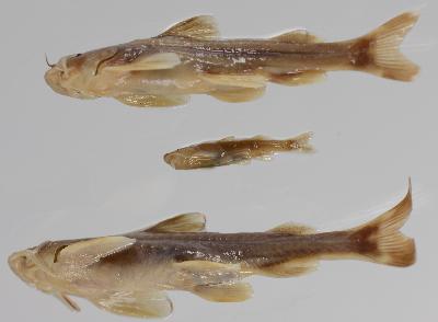
Image
Family: Balitoridae
Species: Schistura punjabensis
Cat No: NRM 30380. N=4
Determiner: Åhlander, E 1994
Length:
Preparation: Liquid
Continent/Ocean: Asia
Country: INDIA State/Province: Jammu & Kashmir
District: Municipality:
River Drainage: Indus River Lake Basin:
Ocean:
Locality: Indus River drainage: Jhelum River, left bank at Mohara Power Station intake (Uri site# 4)
Field Number: EIA-94-05
Leg: Åhlander, E et al.
Date: 5 Jul 1994
Object remarks:
Locality remarks: Altitude c. 1450 masl. Turbidity 60 Te/f. Slope ca 2%. Current ca 1000cum/s. Width ca 25-30m. Area fished 270sqm, 90 m, depth to 2m. No shadow. Bottom sand-boulders. Human influence: old intake, huge new intake under construction. Coordinates GPS.
Order: Cypriniformes
Family: Balitoridae
Species: Triplophysa kashmirensis
Cat No: NRM 30381. N=6
Determiner: Kullander, SO 1998
Length:
Preparation: Liquid
Continent/Ocean: Asia
Country: INDIA State/Province: Jammu & Kashmir
District: Municipality:
River Drainage: Indus River Lake Basin:
Ocean:
Locality: Indus River drainage: Jhelum River, left bank at Mohara Power Station intake (Uri site# 4)
Field Number: EIA-94-05
Leg: Åhlander, E et al.
Date: 5 Jul 1994
Object remarks:
Locality remarks: Altitude c. 1450 masl. Turbidity 60 Te/f. Slope ca 2%. Current ca 1000cum/s. Width ca 25-30m. Area fished 270sqm, 90 m, depth to 2m. No shadow. Bottom sand-boulders. Human influence: old intake, huge new intake under construction. Coordinates GPS.
Order: Cypriniformes
Family: Cyprinidae
Species: Crossocheilus diplochilus
Cat No: NRM 30378. N=23
Determiner: Åhlander, E 1994
Length:
Preparation: Liquid
Continent/Ocean: Asia
Country: INDIA State/Province: Jammu & Kashmir
District: Municipality:
River Drainage: Indus River Lake Basin:
Ocean:
Locality: Indus River drainage: Jhelum River, left bank at Mohara Power Station intake (Uri site# 4)
Field Number: EIA-94-05
Leg: Åhlander, E et al.
Date: 5 Jul 1994
Object remarks:
Locality remarks: Altitude c. 1450 masl. Turbidity 60 Te/f. Slope ca 2%. Current ca 1000cum/s. Width ca 25-30m. Area fished 270sqm, 90 m, depth to 2m. No shadow. Bottom sand-boulders. Human influence: old intake, huge new intake under construction. Coordinates GPS.
Order: Cypriniformes
Family: Cyprinidae
Species: Schizothorax esocinus
Cat No: NRM 30377. N=3
Determiner: Åhlander, E 1994
Length:
Preparation: Liquid
Continent/Ocean: Asia
Country: INDIA State/Province: Jammu & Kashmir
District: Municipality:
River Drainage: Indus River Lake Basin:
Ocean:
Locality: Indus River drainage: Jhelum River, left bank at Mohara Power Station intake (Uri site# 4)
Field Number: EIA-94-05
Leg: Åhlander, E et al.
Date: 5 Jul 1994
Object remarks:
Locality remarks: Altitude c. 1450 masl. Turbidity 60 Te/f. Slope ca 2%. Current ca 1000cum/s. Width ca 25-30m. Area fished 270sqm, 90 m, depth to 2m. No shadow. Bottom sand-boulders. Human influence: old intake, huge new intake under construction. Coordinates GPS.
Order: Cypriniformes
Family: Cyprinidae
Species: Schizothorax labiatus
Cat No: NRM 41345. N=1
Determiner: Delling & Kullander 1998
Length:
Preparation: Liquid
Continent/Ocean: Asia
Country: INDIA State/Province: Jammu & Kashmir
District: Municipality:
River Drainage: Indus River Lake Basin:
Ocean:
Locality: Indus River drainage: Jhelum River, left bank at Mohara Power Station intake (Uri site# 4)
Field Number: EIA-94-05
Leg: Åhlander, E et al.
Date: 5 Jul 1994
Object remarks:
Locality remarks: Altitude c. 1450 masl. Turbidity 60 Te/f. Slope ca 2%. Current ca 1000cum/s. Width ca 25-30m. Area fished 270sqm, 90 m, depth to 2m. No shadow. Bottom sand-boulders. Human influence: old intake, huge new intake under construction. Coordinates GPS.
Order: Cypriniformes
Family: Cyprinidae
Species: Schizothorax plagiostomus
Cat No: NRM 30376. N=9
Determiner: Åhlander, E 1994
Length:
Preparation: Liquid
Continent/Ocean: Asia
Country: INDIA State/Province: Jammu & Kashmir
District: Municipality:
River Drainage: Indus River Lake Basin:
Ocean:
Locality: Indus River drainage: Jhelum River, left bank at Mohara Power Station intake (Uri site# 4)
Field Number: EIA-94-05
Leg: Åhlander, E et al.
Date: 5 Jul 1994
Object remarks:
Locality remarks: Altitude c. 1450 masl. Turbidity 60 Te/f. Slope ca 2%. Current ca 1000cum/s. Width ca 25-30m. Area fished 270sqm, 90 m, depth to 2m. No shadow. Bottom sand-boulders. Human influence: old intake, huge new intake under construction. Coordinates GPS.
Order: Cypriniformes
Family: Cyprinidae
Species: Schizothorax sp.
Cat No: NRM 41346. N=2
Determiner: Delling, B 1998
Length:
Preparation: Liquid
Continent/Ocean: Asia
Country: INDIA State/Province: Jammu & Kashmir
District: Municipality:
River Drainage: Indus River Lake Basin:
Ocean:
Locality: Indus River drainage: Jhelum River, left bank at Mohara Power Station intake (Uri site# 4)
Field Number: EIA-94-05
Leg: Åhlander, E et al.
Date: 5 Jul 1994
Object remarks:
Locality remarks: Altitude c. 1450 masl. Turbidity 60 Te/f. Slope ca 2%. Current ca 1000cum/s. Width ca 25-30m. Area fished 270sqm, 90 m, depth to 2m. No shadow. Bottom sand-boulders. Human influence: old intake, huge new intake under construction. Coordinates GPS.
Order: Siluriformes
Family: Sisoridae
Species: Glyptothorax pectinopterus
Cat No: NRM 30379. N=3
Determiner: Åhlander, E 1994
Length:
Preparation: Liquid
Continent/Ocean: Asia
Country: INDIA State/Province: Jammu & Kashmir
District: Municipality:
River Drainage: Indus River Lake Basin:
Ocean:
Locality: Indus River drainage: Jhelum River, left bank at Mohara Power Station intake (Uri site# 4)
Field Number: EIA-94-05
Leg: Åhlander, E et al.
Date: 5 Jul 1994
Object remarks:
Locality remarks: Altitude c. 1450 masl. Turbidity 60 Te/f. Slope ca 2%. Current ca 1000cum/s. Width ca 25-30m. Area fished 270sqm, 90 m, depth to 2m. No shadow. Bottom sand-boulders. Human influence: old intake, huge new intake under construction. Coordinates GPS.
Image
Page generated in 0.973 seconds
Powered by Collection Presenter 0.7beta17a. Data extracted from the Ichthyology Database of the Swedish Museum of Natural History, and made available with no claim of accuracy or correctness and for non-commercial use only..